- English
- Spanish
- Korean
- Filipino
- Armenian
- Chinese (Simplified)

Freshwater Aquatic & Riparian
Prev
Pelagic
Next
Coastal Wetlands
Habitat Overview
Freshwater Aquatic and Riparian ecosystems are defined as the intermediary zones that occur between fully terrestrial areas and watercourses or water bodies. These ecosystems share a set of unique qualities due to their soil and vegetation characteristics, which are strongly impacted by the free or unbound water present in the earth.
There are 28 distinct drainage basins in the Santa Monica Bay watershed, encompassing creeks, streams, and depressional freshwater wetlands—with more located in the north part of the Bay watershed than the south.
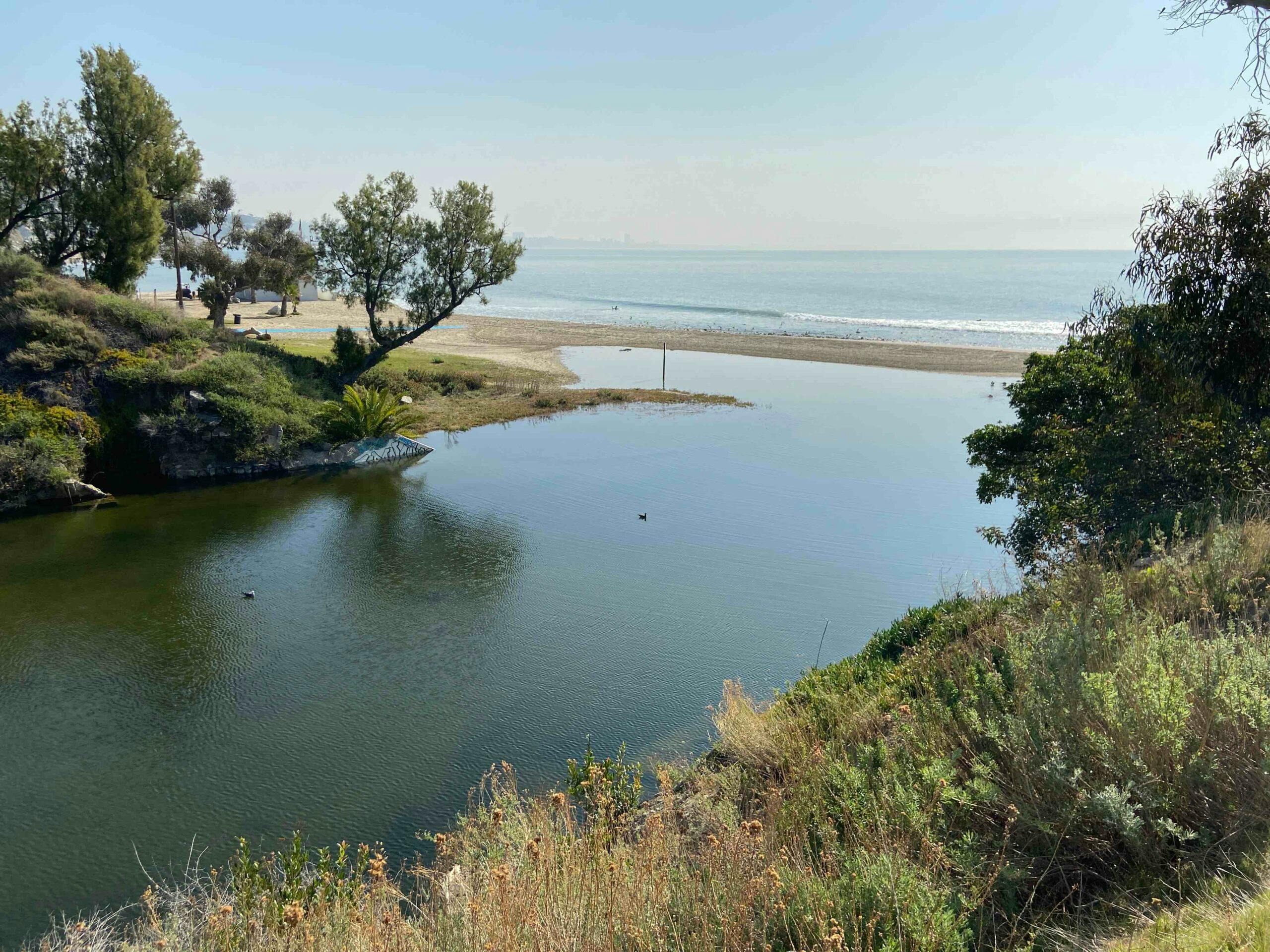
At one time, the Santa Monica Bay watershed was covered with a web of creeks, streams, and depressional freshwater wetlands that were fed by seasonal rains and natural springs (Stein et al. 2014). Many of the natural streams in the watershed were intermittent, with the greatest flows occurring in the wet season during winter. The streams from the eastern Santa Monica Mountains and the northern part of the Palos Verdes Peninsula would flow out of the hills and onto the coastal plain, where they would meander or braid before gradually making their way to the ocean through the once-expansive Ballona Wetlands.
In the north, Malibu Creek is the largest un-channelized creek in the Bay watershed. Smaller drainage basins are present throughout the Santa Monica Mountains. Many in the eastern Santa Monica Mountains are confined to concrete channels for at least part of their lengths.
In the central Bay, the Ballona Creek drainage basin dominates. At 130 square miles, it is the largest sub-watershed draining into Santa Monica Bay. Ballona Creek drains portions of west central Los Angeles and several other cities, as well as the southeastern portion of the Santa Monica Mountains. Most of Ballona Creek was channelized in the 1930s for flood control purposes, and consequently, little riparian habitat remains.
Smaller drainage basins can be found throughout the South Bay and the Palos Verdes Peninsula. Most of these have been buried or replaced with storm drains (LA Creek Freak 2012).
In a natural state, these habitats comprise the stream or river and the stream or river banks that the water flows through or over at higher water levels. These banks are part of the flood plain, where sediment is held in place by the roots of the many types of vegetation found naturally in these areas, e.g., grasses, sedges, shrubs, and trees. When considered together, these zones slow water flows, allow for water to soak into the ground, and capture sediment and pollutants from the watershed around them, while supporting many species of animals, as listed above. In turn, healthy riparian zones supply downstream areas with water and sediments needed to maintain beaches and rocky reefs via natural patterns of erosion and transport.
Why Is a Healthy Freshwater Aquatic and Riparian Habitat Important?
These freshwater aquatic areas and the surrounding riparian zone provide important habitats for many plants, invertebrates, fish, amphibians, reptiles, and birds.

Biodiversity
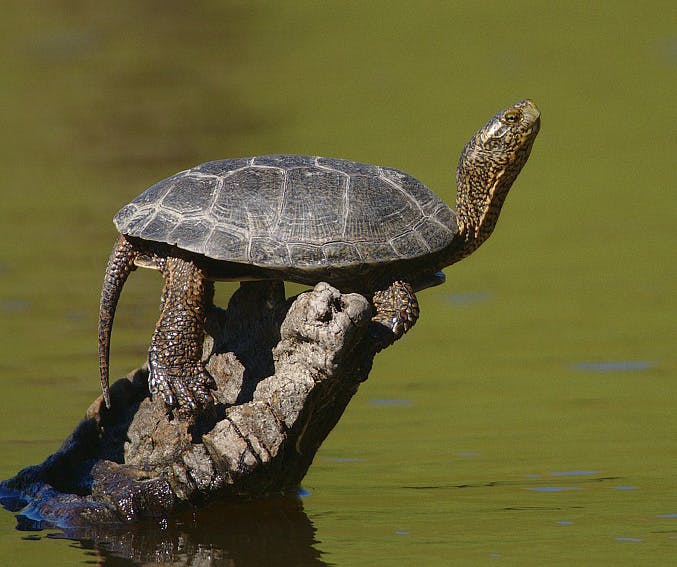
There is an amazing diversity of life that persists in the freshwater and riparian areas across the Santa Monica Bay Watershed. These habitats support migratory species and others, like pumas and steelhead trout, that have large ranges beyond the watershed. Others like tree frogs, reg legged frogs, California newts and western pond turtles that live year-round in the rivers, streams, wetlands, and trees. The preservation of these species and their habitat is a high priority for local, state, and federal programs.
Degradation
Freshwater aquatic/riparian habitat areas have been negatively impacted by urban development, invasive species, pollution, and imported water. The roads, bridges and culverts used to provide vehicular access to most areas in the Santa Monica Bay Watershed alter the amount of water, the amount or type of sediment it transports, and the flow rate often resulting in severe erosion. Some bridges and dams become barriers for migratory fish and other organisms. Runoff from streets and parking lots transports pollutants, such excessive nutrients from animal waste, paint, metals, gasoline, motor oil and diesel. These pollutants are compounded by other negatives like introduced predators, and invasive plants, threatening the health and survival of local species and poor habitat quality.
Climate Change
The local effects of climate change are warming air and water temperatures, drought, and increased intensity of precipitation, when storms occur. Water temperatures can rise above tolerable temperatures for some species, and inevitably reduce concentrations of dissolved oxygen in the water, which can suffocate aquatic species. Drought conditions can lead to plants dying back due to heat and a lack of water, leaving stream banks vulnerable to erosion. The increased intensity of precipitation leads to larger surges of water furthering plant loss and erosion.

Restoration Success
Fortunately, there are some success stories involving the restoration of sections of streams, cleaning up pollution at municipal and industrial scales, and reintroducing species back to these habitats. Ongoing monitoring and investments to support this work can improve these waterways and increase the habitat values for the ecosystem. Cleaner waterways and healthier ecosystems provide conditions that are more effective at filtering water as it percolates into the ground water, better for public health, while creating more enjoyable recreation.

Primary Challenges
Urban Development
While a few streams in the Santa Monica Mountains, such as Arroyo Sequit, Cold Creek, and Solstice Creek, remain in relatively natural states, coastal sprawl and urban development in the Los Angeles region have left little natural habitat in the riparian zone and surrounding areas of the Santa Monica Bay watershed. In addition, efforts to prevent flooding and tame the intermittent but potentially massive flows of the creeks in the area resulted in the channelization of Ballona Creek and most of its tributaries.
When it rains, impervious surfaces in the watershed and in creek channels, like asphalt and concrete, prevents rainwater from soaking into the ground, resulting in more freshwater flushing out to the sea and less freshwater recharging aquifers.
Drought
California’s severe drought poses different problems—many of the normally flourishing streams in the Santa Monica Mountains become seasonally dry, eliminating a freshwater habitat for many organisms. The summer of 2015 was the first time this has happened in 25 years (Lee Kats, pers. comm. 21 August 2015).
Drought events make the difference between the heavily undeveloped and less developed areas even starker. Excessive outdoor water use in developed parts of the upper watershed leads to runoff, which causes many historically intermittent streams to flow year-round today and changes their character and while efforts are being made to curb this due to the drought, it is still occurring. Furthermore, this runoff often contains pollutants, such as fertilizers, and picks up others from surrounding development, which puts wildlife and public health at risk.
Damming and Other Human Impacts.
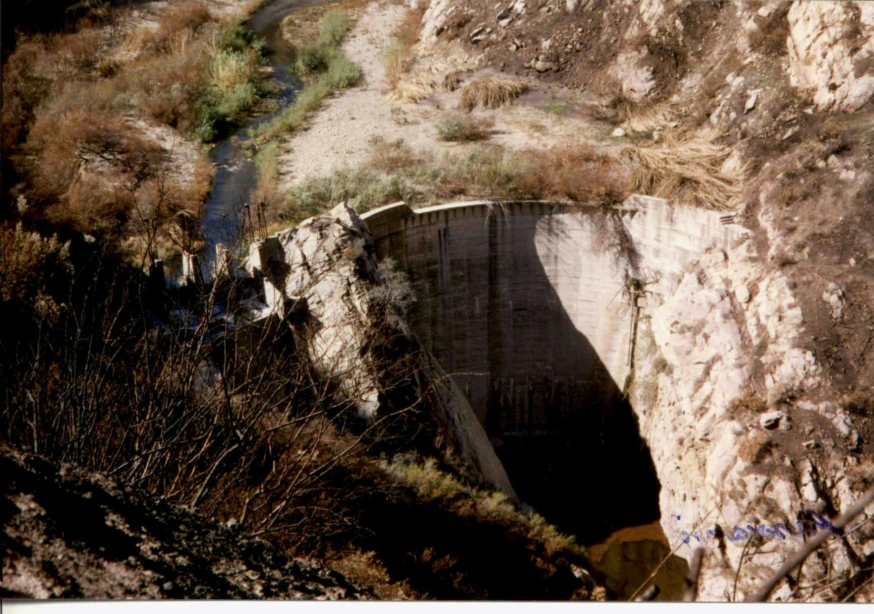
The erection of dams, road crossings, and other barriers in streams has resulted in the loss of riparian and aquatic habitats for many species. In fact, more species were listed as threatened or endangered in these habitats than any other habitat in the Bay and its watershed, except for terrestrial habitats.
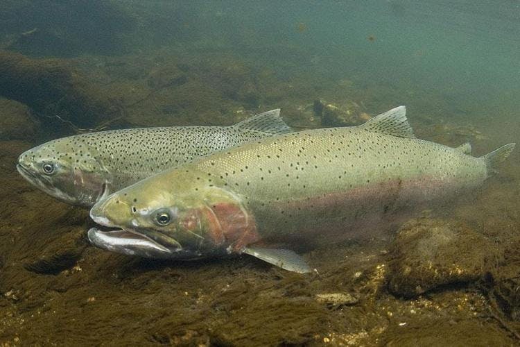
More than 80% of southern steelhead trout (Oncorhynchus mykiss irideus) spawning habitat and 60% of their rearing habitat is inaccessible in Malibu Creek as a result of these barriers (California Trout 2006). Barriers are found in almost every creek within the Santa Monica Mountains. Removal of instream barriers in Arroyo Sequit in 2017 resulted in return of steelhead trout, as did removal of the Rodeo Grounds Berm in lower Topanga Creek in 2008. Pending restoration projects to improve fish passage are proposed for Big Sycamore, Solstice, Topanga, and Trancas creeks.
Invasive Species
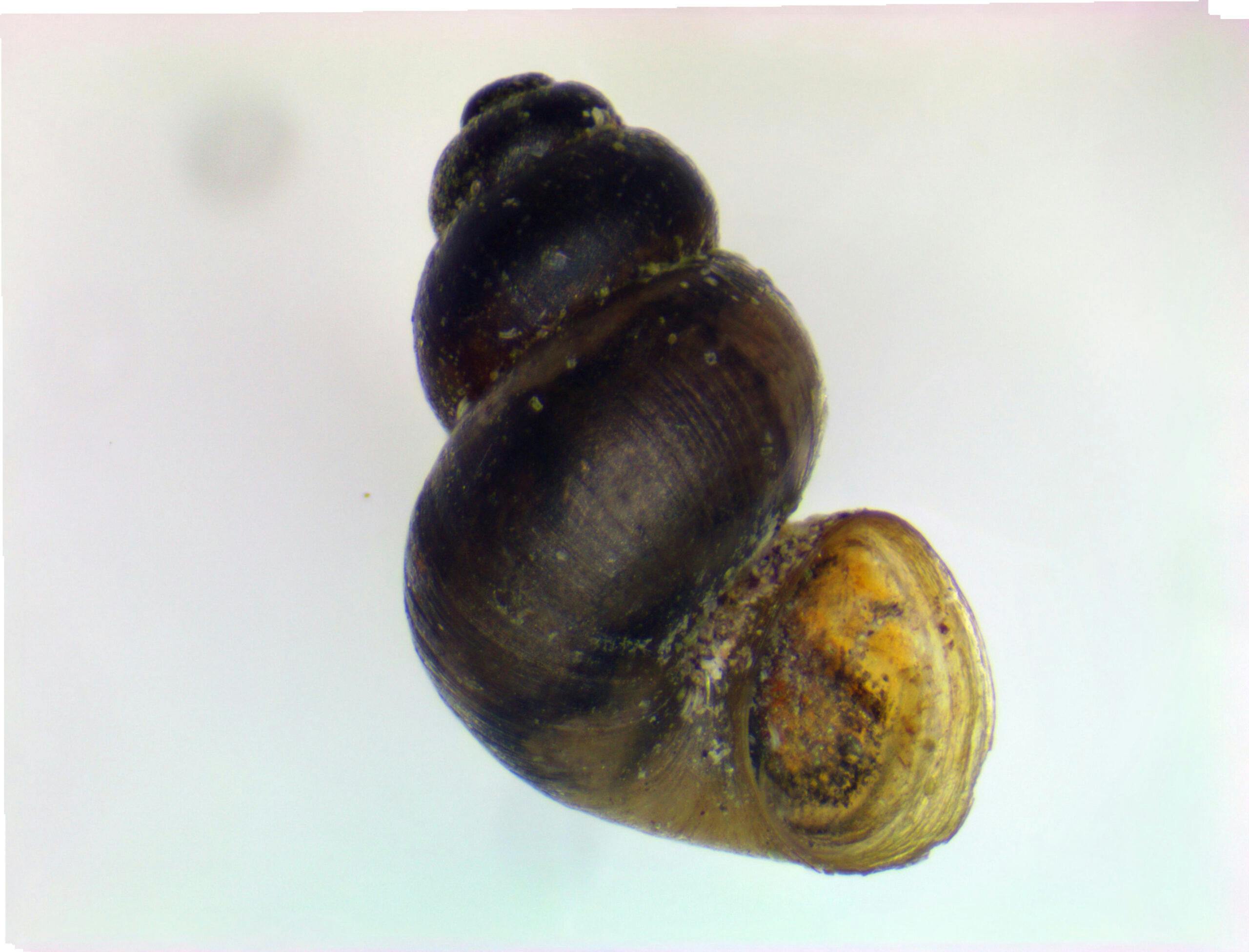
Riparian and freshwater aquatic habitats have also become home to spreading invasive species, such as the New Zealand mudsnail (Potamopyrgus antipodarum), Louisiana red swamp crayfish (Procambarus clarkii), American bullfrog (Lithobates catesbeianus), aquarium fish, mosquito fish (Gambusia affinis), largemouth bass (Micropterus salmoides), and others. Year-round flows in once-intermittent streams are partly responsible.


2015 Habitat Condition
Read more about freshwater aquatic and riparian habitat conditions through our data and research published in the 2015 State of the Bay Report.

Taking Action
Learn more about the work being done by SMBNEP partners and The Bay Foundation to protect and improve the Bay’s Freshwater Aquatic & Riparian habitats.
Learn More

Amphibian and plant communities in the Santa Monica Bay watersheds are facing significant declines due to habitat loss, invasive species, disease, and climate change. To understand these stressors and predict future species persistence, Pepperdine University researchers, funded by the Santa Monica Bay Restoration Commission’s Prop 50 Grant Program, are examining how climate change and other disturbances have affected amphibians and plants in the region. Over three years, the team will survey species such as the California newt and various Ceanothus plants to assess physical changes and predict how these species may fare in a changing climate. The findings will help inform land management strategies and be included in the next State of the Bay Report. Check out this habitat highlight and learn more about what’s to come from this study.
